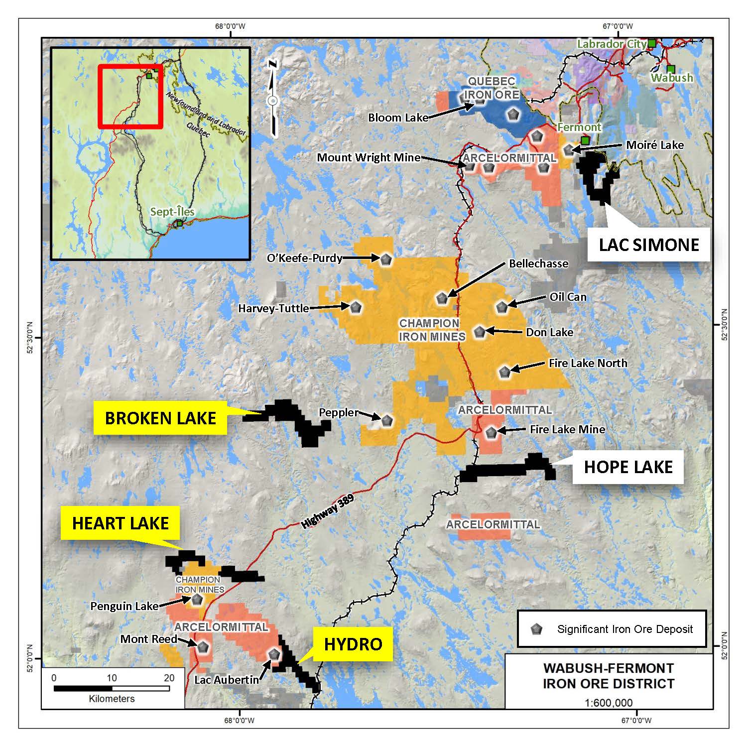
Manning controls a variety of other properties
46 mineral claims
2,400 Ha, in two claim blocks
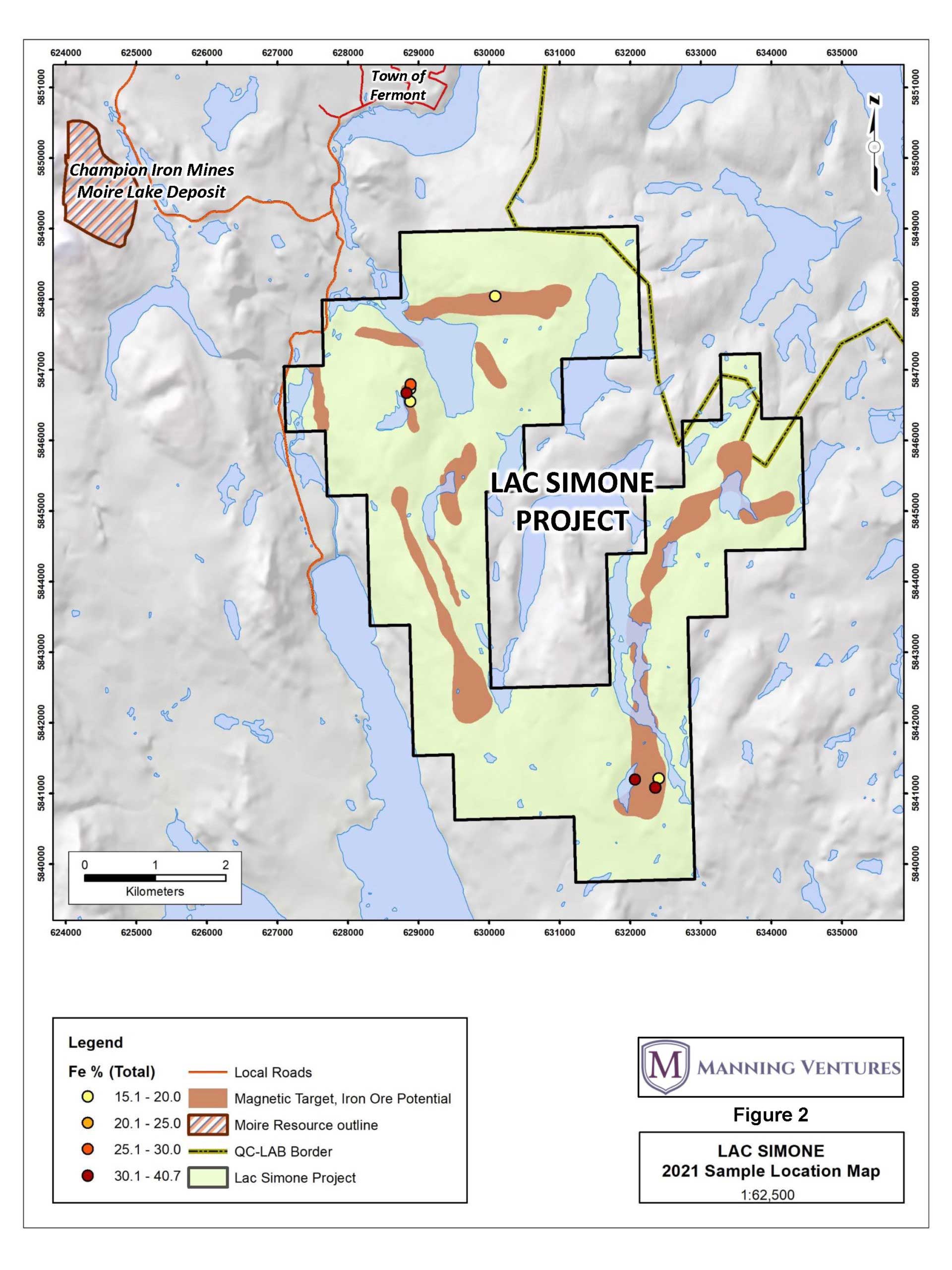
The Lac Simone Property is situated approximately 2- to- 10 km south of Fermont, QC, proximal to Lac Daviault.
The westernmost claims may be accessed via an un-named gravel road south of Fermont that is a continuation of Rue Duchesneau.
Access to the other parts of the Property may be gained by boat in the summer, snowmobile in the winter, or via helicopter or float/ski-plane year-round.
The Property is located approximately 3 km east of Champion Iron Mines’ Moiré Lake Deposit, which contains a mineral resource estimate of 164.0 million tonnes grading 30.5% FeT in the indicated category and 417.1 million tonnes grading 29.4% FeT in the inferred category, at a cut-off grade of 15% FeT.
Management cautions that past results or discoveries on adjacent properties (i.e. Moiré Lake Deposit) may not necessarily be indicative to the presence of mineralization on the Company’s properties (i.e. Lac Simone).
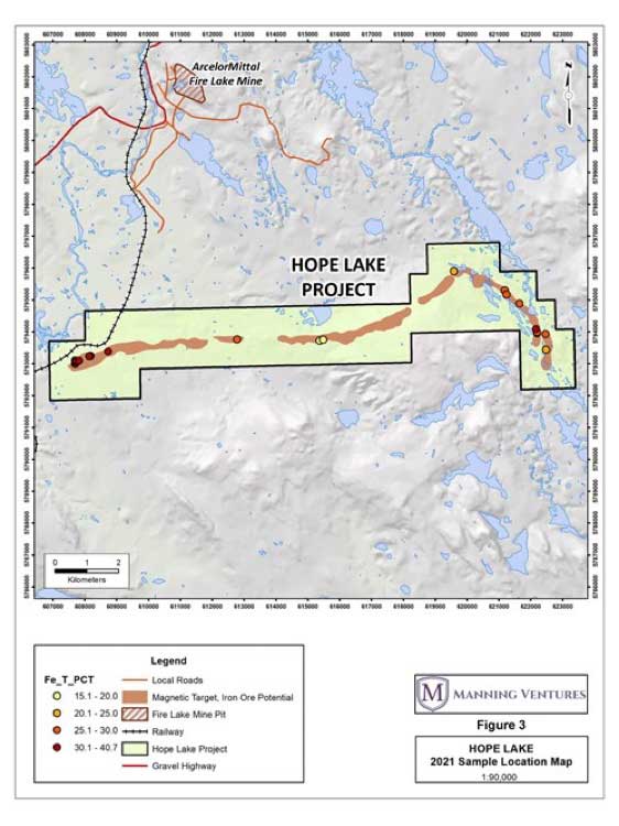
The Hope Lake Property is situated approximately 60 km south of Fermont, QC. Fermont may be accessed directly by road from Quebec City by way of highway.
The westernmost part of the Property may be accessed via a maintenance trail that follows ArcelorMittal’s privately owned Quebec-Cartier Railway line. The trail may be accessed south of the ArcelorMittal’s Fire Lake Mine, which is located approximately 5 km north of the Property.
Access to the eastern parts of the Property may be gained via helicopter or float/ski-plane year-round.
The Property was explored primarily by Jubilee Iron Corporation between 1959 and 1962. Jubilee completed ground and airborne magnetic and geological surveys at the northernmost magnetic anomaly (GM10354, GM10802), and two diamond drill holes (GM11671). In 1959, 12 samples were collected at the east end of the current Property, with results averaging 34.18% FeT (GM10354). One of the two drill holes did not make it to bedrock, while the other hole (DDH HL-2) was drilled vertically and struck lean silicate (grunerite) iron formation from 3.7 m to 23.5 m. Throughout the length of the hole, the iron formation has a consistent southerly dip of 45° to 50°. The core was not sampled, and it is believed that this hole did not intercept the main iron formation of interest.
In 1962, metallurgical testing on samples from 1959 revealed iron concentrations around 68%, initiating a series of advanced geophysical explorations over the decades, including a heli-borne magnetic and radiometric survey by Voisey Bay Geophysics Ltd in 2006, a similar survey with added VLF by Geophysics GPR International Inc. in 2008, and a comprehensive gravimetric, magnetic, and LIDAR survey by Fugro Airborne in 2011. Champion Iron Mines further explored the property in 2011 and 2013, analyzing samples from various outcrops which averaged 28.7% and 33.7% total iron, respectively, confirming high-grade quartz-hematite +/- magnetite iron formations on-site.
The Property is located 6 km south of Arcelor Mittal’s Fire Lake Mine which has been in operation since 2006.

A 4,524-ha property, features an approximately 18-km long trend of iron formation that has been historically drill-tested, and a well-mineralized interval exceeding 84 m reported, although no assays were documented (GM04504B). A 6 km long belt of highly magnetic rocks in the area, that has not yet been drill-tested, has been mapped as a magnetite-rich iron formation and represents a prime exploration target. The project contains magnetic signatures and geological mapping that suggest structural thickening and possibly over-turned sequences of rocks that have the potential to create favorable iron formation horizons.
A 2,855-ha property featuring approximately 10-km of linear-style iron formation. Recent drilling, Hole TM15-01 (GM69425), intersected 26.7% Fe over 25.6 m and ended in high-grade iron formation. The claims are along strike with Champion Iron’s ground where iron-formation on the same trend, approximately 6 km away, contains a drill hole with two separate iron formations of 31.2% Fe over 50.8 m and 30.8% Fe over 42.2 m.
A 2,122-ha property, features approximately 12-km of linear-style iron formation. Several historical rock samples, amongst three separate zones, have been collected along the trend and average approximately 32.5% Fe (GM67778). The trend does not have any documented historical drilling.